Crowds, Sculpture by the Sea, Bondi 2024. Photo Charlotte Curd
With up to 450,000 visitors expected over the 18-day exhibition and limited parking in Bondi, the best way to get to and from the event is by public transport. Buses run regularly between the city and Bondi Junction and between Bondi Junction and Bondi Beach.
Visitors are reminded that weekends at Bondi are extremely busy during the event and heavy traffic is expected. Avoid the largest crowds by visiting on a weekday instead.
TRAVEL TIPS
- Plan ahead. It’ll be very busy on weekends, so visit on a weekday if you want to avoid the largest crowds. Map out your visit and know where your nearest transport options are.
- Leave the car at home & catch public transport. Parking in Bondi is very limited and heavy traffic is expected, particularly on weekends. Catch Metro to Martin Place to connect with buses to Bondi Beach. Trains run regularly to Bondi Junction on the T4 Eastern Suburbs Line, where you can change for buses to the beach or consider walking down to the beach instead to avoid the queues. Visit transportnsw.info to plan your trip. Regular route buses also run regularly between the city and Bondi Junction, and frequent buses will run between Bondi Junction and Bondi Beach.
Don’t forget to tap on & off when catching transport: tap your Opal card or use a contactless payment method such as your major debit/credit card to tap on and off when catching transport to the event. If you’re using your Opal card make sure to top up your card in advance using the Opal Travel App to avoid queues at machines.
- Don’t forget to tap on & off when catching transport: tap your Opal card or use a contactless payment method such as your major debit/credit card to tap on and off when catching transport to the event. If you’re using your Opal card make sure to top up your card in advance using the Opal Travel App to avoid queues at machines.
PUBLIC TRANSPORT
- A number of regular route buses run to Bondi Junction and Bondi Beach from the city and eastern suburbs.
- You can also catch T4 Eastern Suburbs Line trains to Bondi Junction to connect with buses to the beach.
- Frequent buses will run between the junction and the beach however please keep in mind that Bondi is typically very busy on weekends, so visitors are reminded to be patient and expect delays during peak periods. Avoid the largest crowds by visiting the sculptures on a weekday instead.
- For bus and train timetable info plan your trip using the Transport for NSW Trip Planner.
Getting there
From the Eastern Suburbs to Bondi Junction and/or Bondi Beach:
- Route 333: City to Bondi Beach via Bondi Junction (Stand A) services run frequently daily.
- Route 381: Bondi Junction to Tamarama loop services run daily.
- Route 380: Watsons Bay to Bondi Beach via Military Rd services run daily. On weekends, additional services between Bondi Junction and North Bondi will run approximately every 10 minutes from 9:30am until 4:30pm.
- Route 360: North Clovelly to Bondi Junction services run daily. Change at the junction for buses to the beach.
- Route 362 (weekends only): Coogee to Bondi Beach via Bronte and Tamarama services run on weekends only. Additional services will run to Bondi Beach and Coogee every 15 minutes between 9:30am and 7pm.
From the City to Bondi Beach:
- Route 333: City Circular Quay to Bondi Beach via Bondi Junction, making stops along Elizabeth St at Martin Place, St James and Museum stations before continuing via Oxford St to Bondi Junction and Bondi Beach.
- You can also catch T4 Eastern Suburbs line trains to Bondi Junction from Central, Town Hall or Martin Place for a faster trip, then change for buses down to the beach.
Getting home
Buses back to Bondi Junction and to the city will run regularly from Bondi and Tamarama beaches:
From Campbell Parade at Bondi Beach to Bondi Junction / City:
- Route 333: services back to the City Circular Quay and Bondi Junction run frequently on weekdays and weekends.
- Route 380: services to Bondi Junction and Watsons Bay run regularly on weekdays. On weekends additional services will run back to Bondi Junction between 2pm and 7.30pm approximately every 10 minutes.
From Tamarama Marine Dr at Tamarama Beach to Bondi Junction / Coogee:
- Route 381: services back to Bondi Junction will run every 10 minutes until 7pm on weekends.
Route 362 (weekends only): services to Coogee Beach via Tamarama. Additional services will run between Bondi Beach and Coogee every 15 minutes between 9:30am and 7pm.
PARKING RESTRICTIONS – SPECIAL EVENT CLEARWAYS
Street parking will be particularly limited on weekends with special event clearway parking restrictions in place on Bondi Rd to accommodate the additional bus movements by increasing road capacity.
Special event clearway parking restrictions will be in effect each weekend of the event on Saturday 18 and Sunday 19 October, Saturday 25 and Sunday 26 October, and Saturday 2 and Sunday 3 November at the following times and locations:
- 7am to 2pm: Bondi Rd from Old South Head Roadat Bondi Junction to Sandridge St at Bondi Beach.
- 12pm midday to 7pm: Bondi Rd from Sandridge St at Bondi Beach to Oxford St at Bondi Junction.
- 8am to 4pm: Campbell Pde between Queen Elizabeth Drive and Beach Rd at Bondi Beach (southern side)
What are special event clearways?
Special event clearways are strict no-parking zones for all vehicle types and apply even to local residents or TNSW Mobility Scheme Permit holders. Vehicles left in clearways will be towed away and a fee applies.
Look for the bright yellow special event clearway signs and check them carefully when parking. If your vehicle is towed, you can search your vehicle registration at the Find My Car website to find its new location, or alternatively call 132 701 to speak to an operator.
Visit Live Traffic NSW for real-time updates on traffic conditions.
PLEASE NOTE – private/coach parties. There is no coach access to Tamarama Beach, and heavy fines will apply to any coach and driver found in the area without Council authorisation.
EASY WALKING TOUR ROUTES
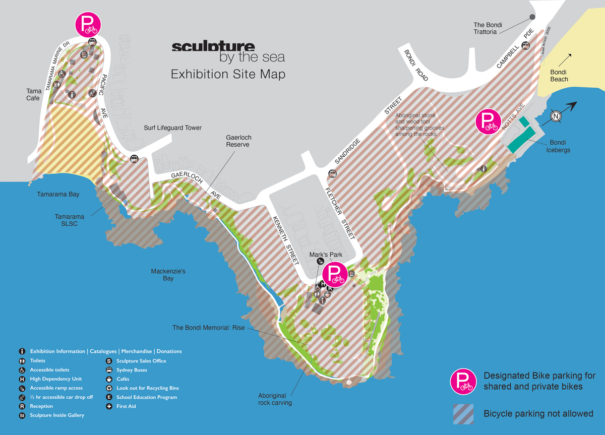
We have come up with some suggested easy walking routes whereby you can see almost all of the exhibition while avoiding most of the stairs. The blue route indicates a walking tour specifically for those not comfortable with stairs or walking long distances, focusing on Marks Park, where you will also find the Sculpture Inside gallery which showcases artists’ smaller works and newly installed accessible toilets. The purple route indicates a walking tour for those who are comfortable with some stairs, moderate slopes and walking over 1km. You can download the map here.

RECOMMENDED WALKING TOUR ROUTE
The coastal walk around the exhibition looks a little different this year. Due to the rock fall that occurred earlier this year, part of the regular route will be closed off. See our map for our recommended walking route. Please note that the first section of the route will have a one way walking system will be in place on the weekends, as indicated by the arrows. Starting from Notts Ave, heading south through to the entrance of Marks Park. The recommended walking route is approximately 2km long and includes many stairs. If long distances or staircases are an issue for you, please see our Accessibility Information below.

INFORMATION FOR RESIDENTS
To minimise the impact on local residents, there will be restricted access zones for vehicles. Special permits for parking in the streets that are closed to commuter traffic are being organised for residents living in those streets. An application will be sent to those residents with instructions on how Council is making access to your street easier for you.
If you need to speak to someone throughout the event about a parking issue, contact Council’s Customer Service Centre between 8.30am–5pm, Monday – Friday, on 9369 8000. Outside these hours call the Parking Patrol Officers on 0414 369 801 or 0414 369 802.
ROAD CLOSURES
For the safety of the large crowds expected to visit the art exhibition, a number of road closures will be in place to manage large pedestrian movements around the coastal walk.
7:30am to 6:30pm daily road closures from Friday 17 October until Monday 4 November:
- Ashley St between Turner St and end of lane
- Bayview St between West of Bronte Marine Drive and end of street
- Birrell St between Tamarama St and Cross St (Eastbound lanes only)
- Carlisle St between Dellview St and end of street
- Cross St between Birrell St and Turner St (Southbound lanes only)
- Darling St between Alfred St and Ashely St
- Fletcher St between Sandridge St and Marks Ln
- Illawong Ave from Farrellys Ave (Southbound lanes only)
- Kenneth St between Alexander St and Marks Ln
- Marks Ln between Kenneth St and Fletcher St
- Notts Ave between Campbell Parade and end of street
- Rowland Ave between Fletcher St and Wilga St
- Silvia St between Fletcher St and end of street
- Turner St between Cross St and Ashley St (Eastbound lanes only)
- Wilga St between Sandridge St and end of street
- Wolaroi Cres between Thompson St and end of street
Road closures will be manned by accredited traffic controllers to allow access for Emergency Services, local residents and authorised vehicles when required.
For a map and more details of the road closures and changed traffic conditions, visit www.livetraffic.com or https://transportnsw.info/events/sculpture-by-sea
ONE-WAY STREETS
In some local streets near the coastal walk, traffic flow will be changed from two-way to one-way for the duration of the event. These changes are in effect for the safety of pedestrian movement as well as local access. Traffic conditions will return to normal from 10am Monday 6 November after the event.
One-way street from 9am Friday 18 October through until 10am Monday 4 November:
- Ashley St between darling St and Turner St
- Mirimar Avenue between Hewlett Street and Thompson Street (northbound)
- Thompson Street between Mirrimar Avenue and Ashley Street (westbound)
- Turner Street between Cross Street and Ashley Street (westbound)
- Cross St northbound only from Turner St to Birrell St
- Birrell St westbound only from Cross St to Tamarama St
- Marks Ln southbound only from Fletcher St to Kenneth St
One-way street from 10am, Fri 18 Oct until 10am, Mon 4 Nov:
- Gaerloch Avenue between Pacific Avenue and Kenneth Street (southbound)
- Dellview Street between Gaerloch Avenue and Fletcher Street (northbound)
For a map and more details of the road closures and changed traffic conditions, visit www.livetraffic.com or https://transportnsw.info/events/sculpture-by-sea
TRAVELLING BY BIKE
You can ride a bike to and from the event. There is free bike parking available at both Tamarama and Marks Park. These bike parking areas are for parking your own bike, or you can rent a dockless share bike and ride it one way then walk or catch the bus back again. Please note that bikes are not to be parked within the event area (shown on the map). You can download the map here